


NOAA has raised the odds of a historically powerful El Niño event to 90 percent for the coming fall and winter seasons.
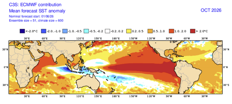
The National Oceanic and Atmospheric Administration’s Climate Prediction Center issued its August 2026 forecast showing a 90 percent chance this El Niño will rank among the strongest on record, up from 81 percent in the July outlook. The agency now predicts a 69 percent chance of a historic event that would exceed the strength of all previous El Niño events dating back to 1950, with sea surface temperature anomalies already exceeding plus-2.0 degrees Celsius in the eastern equatorial Pacific.
Michelle L’Heureux, a physical scientist at NOAA’s Climate Prediction Center, said that the agency’s team has become more confident in the possibility of a very strong El Niño by the end of this year.
“There is a greater than 90% chance of a ‘very strong’ El Nino, which is the highest chance to date, and expresses our confidence in the growth and development of a potentially historic El Nino event,” L’Heureux said.
She added a critical caveat about local impacts: “The data is very clear that we can be more confident in certain impacts occurring during strong and very strong El Nino, but it is really important to emphasize that even if this ends up being a historic El Nino, there will be impacts in some locations that do not align with the expected El Nino impact.”

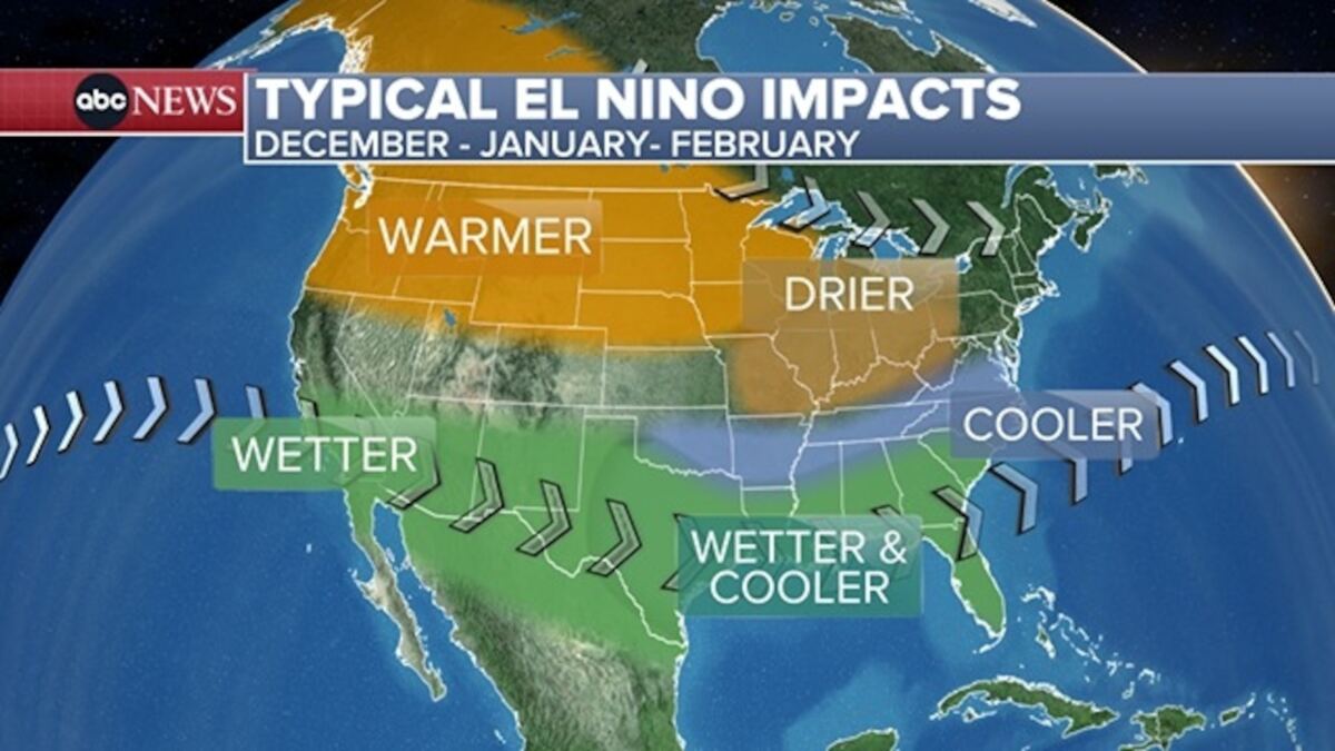
Johanna Infanti, a meteorologist at the NOAA’s Climate Prediction Center, explained that experts are predicting above-normal precipitation during the fall and winter seasons over much of the Southern US.
“The highest probabilities for above-normal precipitation are over the Gulf States and parts of the Southeast to Mid-Atlantic, indicating the areas where we have the most confidence,” Infanti said.
The four states most likely to see significant snow over the coming winter are New Hampshire, New York, Vermont and California, specifically the Sierra Mountain range, according to a map from the outlet. More broadly, the Gulf Coast, Southeast and Mid-Atlantic regions face elevated odds of heavy rainfall and potential flooding.
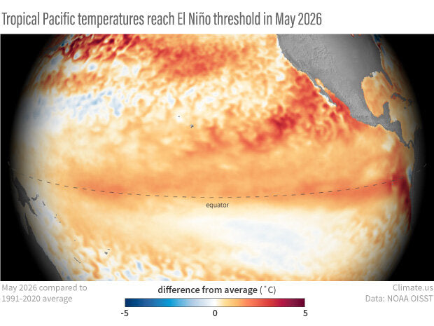
NOAA’s August forecast revealed the dramatic jump to 90 percent confidence in a very strong event, building on months of steadily intensifying predictions. The July Niño index values reached plus-1.4 degrees Celsius in Niño-3.4, plus-1.7 degrees Celsius in Niño-3, and plus-2.9 degrees Celsius in Niño-1+2, with subsurface temperature anomalies hitting plus-10.0 degrees Celsius at depth. Low-level westerly wind anomalies and upper-level easterly wind anomalies extended across the equatorial Pacific, while convection and rainfall were enhanced from the central to eastern Pacific and suppressed over Indonesia. The traditional and equatorial Southern Oscillation indices were significantly negative, with values near two standard deviations during July.
The event’s rapid intensification has drawn comparisons to the 1997-98 and 1982-83 super El Niños, with some models forecasting Ocean Niño Index values crossing 3 degrees Celsius, a level reached only once before in January 1878. Zeke Hausfather, a climate scientist, noted that the gap between the strongest and fifth-strongest El Niño of the past 150 years is only about 0.5 degrees Celsius, and current models are forecasting something outside the envelope of anything ever observed.
NOAA’s next ENSO Diagnostics Discussion is scheduled for release in September 2026.