A Nor’Easter storm is expected to hit the US next week, and experts have identified the cities likely to be affected.
Recently, the US has experienced a wave of freezing weather, following a significant cross-country storm system that resulted in the cancellation of over 1,900 flights within, into, or out of the US on Saturday, November 29, according to Flight Aware. Additionally, there were more than 8,000 flight delays.
Chicago O’Hare International Airport alone experienced over 1,000 cancellations. In Indiana, a 45-car pileup on I-70 near Terre Haute was reported as residents dealt with major disruptions on the roads due to snowy conditions.
Unfortunately, these weather challenges might just be beginning, as a Nor’Easter is expected to arrive next week. Here is what you need to know about the impending storm.

The National Weather Service defines a Nor’Easter as a storm that moves along the East Coast of North America, characterized by northeast winds.
These storms can occur at any time of the year, but they are more common from September to April, often being quite severe.
Historical Nor’Easters include the Blizzard of 1888, the Ash Wednesday storm in 1962, and significant Boston snowstorms in January and February of 2015.
Depending on their intensity, Nor’Easters can result in billions of dollars in damage, disrupt transportation, cause coastal flooding, and more.
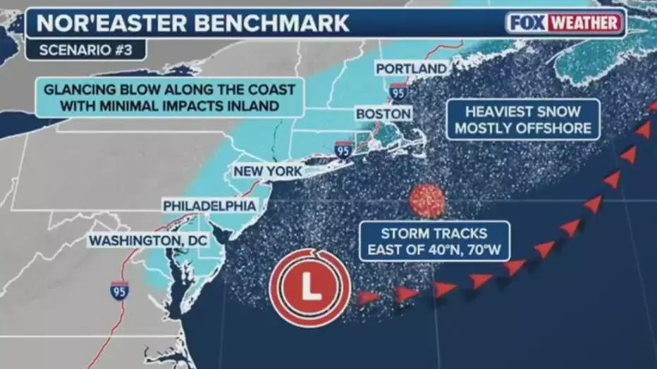
Fox Weather meteorologists predict that snow or rain could affect New York City, depending on how the storm evolves in the coming days.
The meteorologists are tracking a low-pressure system in the western US, which is expected to move east over the next several days. The system’s energy is anticipated to bring snow to the Rockies and High Plains this weekend, before heading to the Midwest on Monday, potentially causing light snow and travel disruptions.

By Tuesday and Wednesday, the system may develop into a Nor’Easter off the East Coast, causing heavier snow along the I-95 corridor. This includes cities like Philadelphia, New York City, and Washington, D.C.
Forecasters suggest that the Northeast could experience significant snow, or rain if warmer ocean air is drawn inland.
The lower Hudson Valley might receive three to five inches of snow on Tuesday, while all of NYC could transition to rain with one to two inches of precipitation.
Northwest New Jersey might see one to three inches of snow on Tuesday, and temperatures in Montana, North and South Dakota, Minnesota, and Wisconsin are expected to plummet to freezing levels.
Meanwhile, today and into tomorrow, December 1, up to 12 inches of snow is anticipated in Utah’s Cottonwoods and Wasatch Plateau, as well as Colorado’s Eastern San Juan Mountains, according to the National Weather Service.
Take care and stay safe out there.

